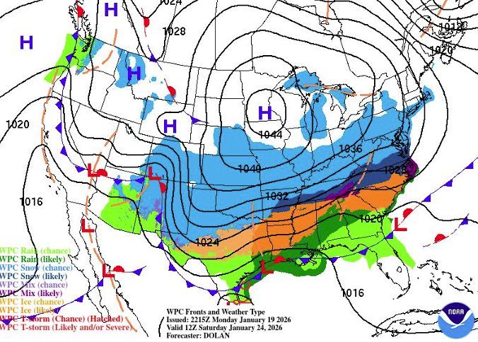
(West Plains, MO)Residents in West Plains and the surrounding southern Missouri region are being urged to prepare for a significant winter storm and “excruciatingly cold” temperatures beginning Friday evening. The National Weather Service (NWS) in Springfield has issued a Winter Storm Watch effective from 6:00 PM Friday through 12:00 PM Sunday.
Snowfall Forecast for West Plains
As the storm track trends northward, forecast snowfall totals for the area have increased. In West Plains and across southern Missouri, the highest amounts are currently expected to be focused in this region. Snowfall projections for West Plains vary depending on the storm’s exact track:
-
Reasonable Worst-Case Scenario: Up to 14 inches of snow.
-
High-End Amount (10% Chance): Approximately 8.8 inches.
-
Likely Minimum: High confidence (85-95%) exists that much of the area will see at least 2 to 4 inches of snow.
Timing and Snow Character
Snow chances will increase after 6:00 PM on Friday, with the highest likelihood of heavy precipitation occurring throughout Saturday. Forecasters expect the snow to be a drier, “fluffier” variety. Because temperatures are predicted to stay below freezing until at least next Tuesday, the snow will likely remain on the ground for several days rather than melting quickly.
Bitter Cold and Dangerous Wind Chills
A Cold Weather Advisory has also been issued from 12:00 AM to 12:00 PM Saturday. Extremely low temperatures and wind chills will accompany the snowfall:
-
Low Temperatures: Ranging from 0°F to 10°F.
-
Wind Chills: Expected to drop between -5°F and -15°F.
-
Duration: Dangerous cold, including single-digit lows and below-zero wind chills, is expected to persist through at least next Tuesday.
Potential Impacts and Safety Precautions
The Winter Storm Severity Index (WSSI) indicates a high probability of major impacts for West Plains. This includes the potential for dangerous or impossible driving conditions and significant disruptions to daily life and infrastructure.
Safety Recommendations:
-
Dress in multiple layers and cover all exposed skin if you must go outdoors.
-
Limit outdoor time to avoid frostbite and hypothermia.
-
Check on elderly neighbors and family members to ensure they have adequate heating.
-
Avoid travel if possible during peak storm hours on Saturday.
Local officials and the NWS will continue to monitor the track of the system as hi-resolution models provide more clarity on hourly onset timing over the next 24 to 48 hours.


